


foncine le haut

bendoush
User
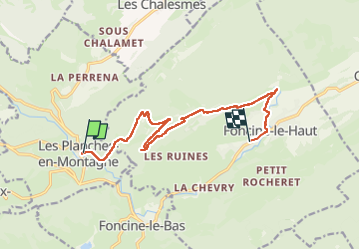

Length
13.6 km

Max alt
1075 m

Uphill gradient
463 m
Km-Effort
19.3 km

Min alt
724 m

Downhill gradient
322 m
Boucle
No
Creation date :
2024-08-05 13:17:37.598
Updated on :
2024-08-05 17:29:40.156
4h11
Difficulty : Difficult

FREE GPS app for hiking
 SityTrail
IGN / Geographical institutes
SityTrail Plus
The world is yours!
About
Trail Walking of 13.6 km to be discovered at Bourgogne-Franche-Comté, Jura, Les Planches-en-Montagne. This trail is proposed by bendoush.
Description
Magnifique !
Positioning
Country:
France
Region :
Bourgogne-Franche-Comté
Department/Province :
Jura
Municipality :
Les Planches-en-Montagne
Location:
Unknown
Start:(Dec)
Start:(UTM)
271236 ; 5171090 (32T) N.
Comments